| |
|
||||||||||||||||
|
|
|
|
|
|
|
|
|
|
|||||||||
|
|
|
||||||||||||||||
| |
|
||||||||||||||||
|
|
|

|
|
||||||||||||||
|
|
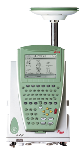
Having operated Lieca Global Positioning equipment since 1995, Kaatskill Mountain Surveyors personnel have earned a reputation for accurate results and on-time delivery. GPS Pre-engineering Control - Precise Coordinates and Elevations in the State Plane Coordinate System. Real Time Mapping - Cost effective observations for wet-land delineation, GIS systems and aerial mapping control networks. Contact Kaatskill Mountain Surveyors to discuss the GPS applications you may need on your project. |
|
|
||||||||||||||
|
|
|
||||||||||||||||
|
|
|
||||||||||||||||
|
|
|
||||||||||||||||
|
|
|
||||||||||||||||
|
|
|
||||||||||||||||
|
|
|
||||||||||||||||
|
|
|
|
|||||||||||||||
|
|
|
||||||||||||||||
|
|
|
||||||||||||||||
|
|
|
||||||||||||||||
|
|
|
|
|
||||||||||||||
|
|
GPS Land Surveying provides one of the most modern and up to date surveying techniques available. KMS presently uses a Leica GPS System. This equipment has been designed to give the performance in accuracy and reliability that the survey and construction industry demands. KMS uses the National GPS Network to obtain accurate positions in the national coordinate system. The Ordnance Survey is fully adopting GPS positioning as the basis of all national coordinate systems. All surveyors who want to take advantage of the new infrastructure will therefore need access to survey-grade GPS equipment. For basic information on GPS please link to Trimble Inc. |
|
|||||||||||||||
|
|
|
|
|
||||||||||||||
|
The partners of the firm include:
* Douglas S. Woodin, L.S. 1977 License No. 49243 * Richard E. Parsons, L.S. 1978 License No. 49317 * Richard G. Braun, L.S. 2000 License No. 050393 |
|
||||||||||||||||
|
|
|
||||||||||||||||
| |
|
||||||||||||||||
 |
|
|
|||||||||||||||
Snippet: Trying to figure out where you are and where you're going is probably one of man's oldest pastimes. Navigation and positioning are crucial to so many activities and yet the process has always been quite cumbersome. Over the years all kinds of technologies have tried to simplify the task but every one has had some disadvantage. Finally, the U.S. Department of Defense decided that the military had to have a super precise form of worldwide positioning. And fortunately they had the kind of money ($12 billion!) it took to build something really good. The result is the Global Positioning System, a system that's changed navigation forever. (Source: http://www.trimble.com/gps/why.html) |
|
||||||||||||||||
|
|
|
||||||||||||||||
| Home
| Company | Quote
| News | Services
| Contact Us
© Copyright Kaatskill Mountain Surveyors 2004. Designed by TemplatesBox.com |
|
||||||||||||||||
|
|
|
|
|
|
|
|
|
|
|
|
|
|
|
|
|
|
|